Geography
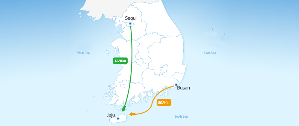
Jeju is a volcanic island in Korea’s South Sea. Seen from the south, the island leans toward the southwest. To the north of the island is a city called Mokpo, 149 kilometers away, while 302 kilometers to the northeast lies Busan. The island is 469 kilometers from Seoul, the nation’s capital. Jeju is separated from mainland Korea by the Strait of Jeju. Immediately to the north of the island is Korea’s South Sea, while to the south is the South China Sea - Jeju serves as the boundary between the two. Turn the map of Korea upside down, and one can see the small island provides a foothold for Korea into the Pacific. This also means that Jeju is at the heart of an area surrounded by Korea, China and Japan, revealing its geopolitical significance.
Jeju sits at 126.08’ – 126.58 east longitude and 33.06’ – 34.00’ north latitude. Marado Island is the southernmost tip of Korea. On the western end of the island is Chagwido Island (part of Hangyeong-myeon). The eastern end is Biyang Lighthouse in Yeonpyeong-ri on Udo Island, while Siruyeo on Chujado Island is the northernmost point of Jeju. According to statistical data from 2004, Jeju is 1,848.2 km2 in area – only 1.86% of the country. Its coastline is 419.95 kilometers long, surrounded by 8 inhabited and 55 uninhabited islands.
Geology
Stretching east-northeast, Jeju is an oblong shape, created by volcanic eruptions that lasted from the late Cenozoic Era (approximately 1.8 – 2 million years ago) to the historical period (Jong-gwan won, 1976; Gi-hwa Park et al, 2000a). At the center of the island is Hallasan Mountain (1,950 meters above sea level). Jeju is populated by 368 volcanic cones that vary in shape and size. Data from geological boring conducted across the island indicates that the island has a bedrock at the bottom, topped with a U Formation, a Seogwipo Formation and lava flow.
Jeju World Natural Heritage
On June 27, 2007, the 31st session of the World Heritage Committee reached a unanimous decision to inscribe Jeju Volcanic Island and Lava Tubes on the UNESCO World Heritage list according to its natural criteria. With the decision, Jeju became South Korea’s first World Heritage Site. The Korean government and Jeju endeavored to inscribe their natural treasure on the UNESCO list since 2001, finally seeing success after six years of dedication.
Jeju Volcanic Island and Lava Tubes comprise three closely-knit heritage sites. Outstanding features of Geomunoreum, together with diverse, accessible volcanic features seen at the two other sites, offer invaluable contributions to volcanic studies around the world.
Definition
Groundwater that flows through aquifers is transmitted through rocks and fissures in the strata to the surface. The point at which the water is discharged at the surface is called a spring, and the water is referred to as spring water.
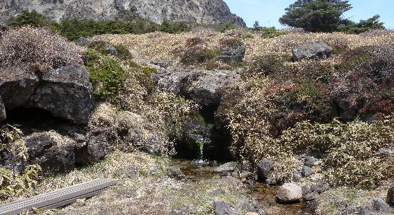
Baeknoksaem Spring –Seohong-dong, Seogwipo, Jeju
(Source: Jeju’s Water and Spring Water, Water Resource Management Master Plan, Jeju Special Self-Governing Province)
Types of Spring Water
Classification by Size of Spring
Seepage or filtration spring – Formed by different sources in an aquifer with small flow rates.
Fracture spring – Formed by groundwater discharged through joints or fractures in sizable rocks.
Tubular spring – Formed by groundwater discharged into a large space such as lava tubes or solution cavities in areas comprised of volcanic rock or limestone.
Classification by Gravity
Depression spring – Formed when the water table reaches the ground surface at points of dramatic change in sloping. Also referred to as a basin spring.
Contact spring – Formed by groundwater that flows over impervious rocks and is discharged through the strata to the ground surface.
Confined spring – Formed by groundwater discharged under pressure through a space or cracks in the confining layer at the top of an aquifer.
Spring in impervious rock – Formed by groundwater discharged through a fracture or tubular channel in impervious rock.
Tubular or fracture spring – Formed by groundwater discharged to the ground surface through lava tubes, solution cavities, or fractures or aquifers in impervious rock.
Characteristics of Spring Water in Jeju
Status
There are 1,023 springs in Jeju – 613 in Jeju City and 410 in Seogwipo. Most are located in low-lying areas at 200 meters above sea level or lower. Some are found in the hills and mountains.
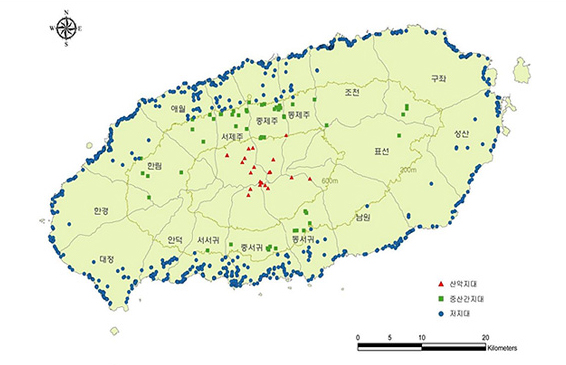
Distribution
(Source: Jeju’s Water and Spring Water)
Use
Prior to the 1980s when Jeju’s public water supply system was inadequate, springs were a crucial source of water for drinking and household use, as well as farming.
According to a survey by the Jeju provincial government in 2013 – 2014, only 373 of the 1,023 springs were in use (36%) while 449 (44%) were not and 376 (37%) were lost or closed. Of the 383 in use, they each served different purposes: 32 for water supply; 5 for water supply and household use; 1 for water supply, household use, and farming; 134 for household use; 6 for household use and farming; and 20 for farming.
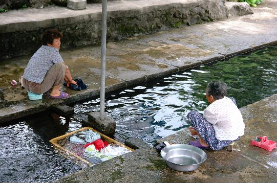
Noknammul Used for Laundry
(Source: Jeju Special Self-governing Province )
Hallasan Mountain, the Power of Jeju
Hallasan Mountain is one of the three most sacred mountains in Korea. Located off the southernmost point of the Korean peninsula, the peak stands 1,950 meters above sea level – the tallest in the nation. Thanks to its biodiversity, Hallasan Mountain is highly regarded by scholars, and was designated as Natural Monument #182 on October 12, 1966 to protect the natural flora and fauna as part of the Hallasan Conservation Zone.
Tracing its origin back to the Quaternary Period of the Cenozoic Era, Hallasan Mountain is a young volcano that was active until 25,000 years ago. Near the mountain are some 360 volcanic cones, adding unique features to the local landscape created by the magnificent Hallasan Mountain standing tall at the center of the island. The beauty that is both benevolent and stern is admired by many, as it reveals a variety of colors in different seasons. The awe-inspiring mountain was designated as a national park on March 24, 1970 and added to the list of UNESCO Biosphere Reserves in December 2002.
Beautiful with primeval charm, Hallasan Mountain and Jeju Island are gifts that God has given to us. An invaluable heritage to be protected and cherished by the world, Jeju Volcanic Island and Lava Tubes became Korea’s first natural heritage to be recognized by UNESCO on June 27, 2007.
Home of Samdasoo – Gyorae Samdasoo Village
Famous for fresh, clean air and Samdasoo, Gyorae Village is home to 300 residents and a wide range of restaurants that serve local food and delicacies. The village is the first in the mountain area to welcome visitors and hikers and offer food and lodging.
The village is 420 meters above sea level. On the hillside of Sangumburi volcanic cone, golden Adonis blossoms despite the frigid winter breeze and heavy snow. When the sun is out shining on the wide swaths of green and silver grass, cows graze in blissful peace.
Q 현재 페이지에서 제공되는 정보에 대해 만족하십니까?
![]()
Tel: (064)780-3300, (without area code) 1636 (say "Jeju Province Development Company" or "Samdasoo")
Fax: (064)784-5020
 https://www.youtube.com/@jejusamdasoo_official
 https://www.instagram.com/samdasoostory/
 https://www.instagram.com/samdasoostory/